Please don’t hijack my possibility to zoom in pictures on mobile (iOS)
There was an app called Exit Strategy that showed you where to stand on the train to maximize your routes, depending on what transfers you were taking.
London's are available at: https://www.ianvisits.co.uk/articles/3d-maps-of-every-underg...
Slightly (un)related: For detailed subway track maps e.g. in Paris https://cartometro.com/en/ is a nice resource. The US is not covered well, though.
Not all of these are correct. For instance, the one for Fulton St Station shows the two J/Z platforms as being on the same level, when in fact they're on two different levels.
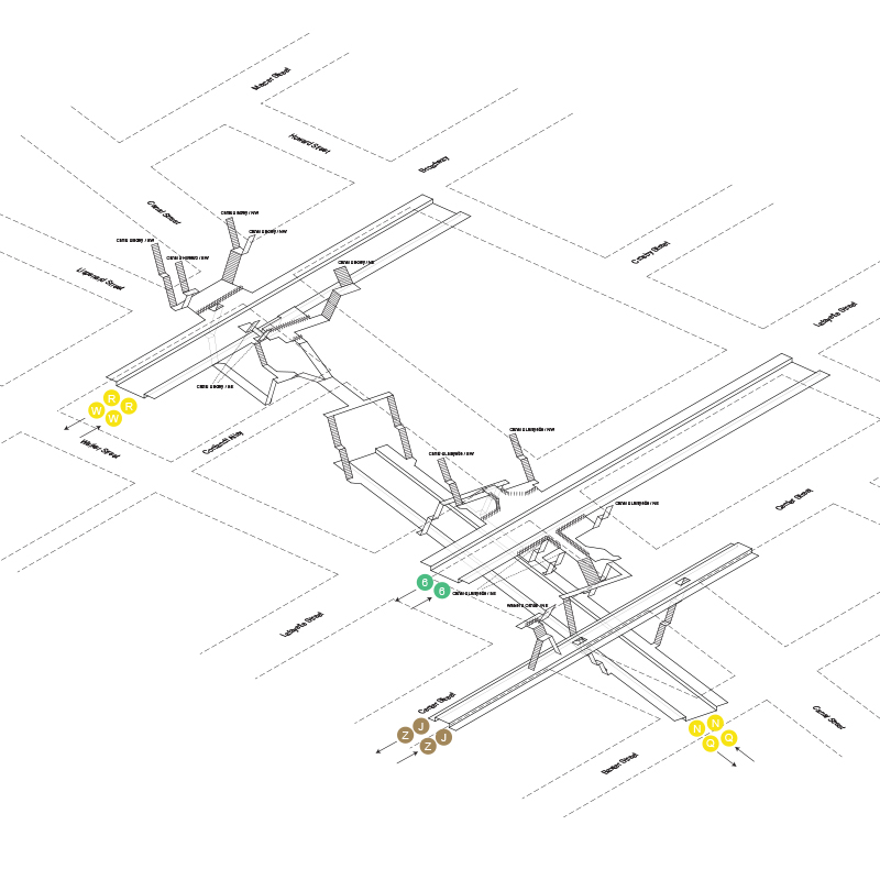
One time I got onto the Q platform from Centre Street by habit before realizing I was supposed to take the 6.
Felt like I somehow broke space and time getting there, and this Escher staircase in Canal Street station confirms it: https://images.squarespace-cdn.com/content/v1/55ababf2e4b064...
In the renderings, why are most of the (what look like) stairs/escalators so steep?
I asked a while back to a NYC city planner the reason they didn't publish station MTA station layouts / exits on gmaps , like you see for example for toyko in gmaps
I was told this was not opened publicly because of terrorist concerns. But if you wanted to get MTA station layouts, it was certainly possible to get them from the city.
I guess we have flipped that page!
A somewhat related idea that's been done for Toronto TTC subway stations is mapping out where the exit/stairs are for your destination station, that way when the doors open they're right there and you don't have to walk down the platform:
* https://theurbangeographer.ca/Subway-Exit-Map
* iOS app: https://efficientttc.weebly.com
* Android: https://recursivepizza.com/#TtcRider_more
I would love to have diagrams like this for Chicago’s CTA but I haven’t found any.
Awesome. I wonder if there’s a way to turn these into actual geographic data. I’d love an app to that will navigate me between platforms at the Fulton St megaplex.
People should do/include Secaucus Junction.
This would be a phenomenal accessibility tool if it included elevators! I've had to carry my rollator up SO MANY STAIRS because times square station is nonsense.
Similarly, this site has subway station layouts for many cities: http://stations.albertguillaumes.cat/
Can this be integrated into the various navigation apps?
This is a fun visualization. I may end up in NYC if my job interviews went well enough to land an offer. Just wrapped up 2nd round yesterday.
Make sure to check out the 3D models tab. That’s definitely the most interesting part of the site!
To the person drawing the stairs, the stairs are not that steep - not even close.
The photography is the best part (of a wonderful website). Kudos to the creator.
The Hong Kong MTR has these as standard.
Why are the stations not labeled? I'm sure this is fine for people who live there and use the subway on a regular basis, but it would be of little help to someone visiting or who just relocated. Even someone visiting a friend in an area they aren't familiar with would be at a disadvantage figuring out which layout to use.
Edit: that said, very cool.
Great but if owner is looking at this, please make the images zoomable on mobile
For those interested in these for other subways around the world, http://stations.albertguillaumes.cat/ has done a lovely job rendering them. It's impressive how many systems are covered.